
Every outdoor enthusiast should go hiking near Asheville, North Carolina, at least once in their lifetime!
Are you looking for some fantastic hikes near Asheville, Western North Carolina? Of course, you are! Otherwise, why would you be here?
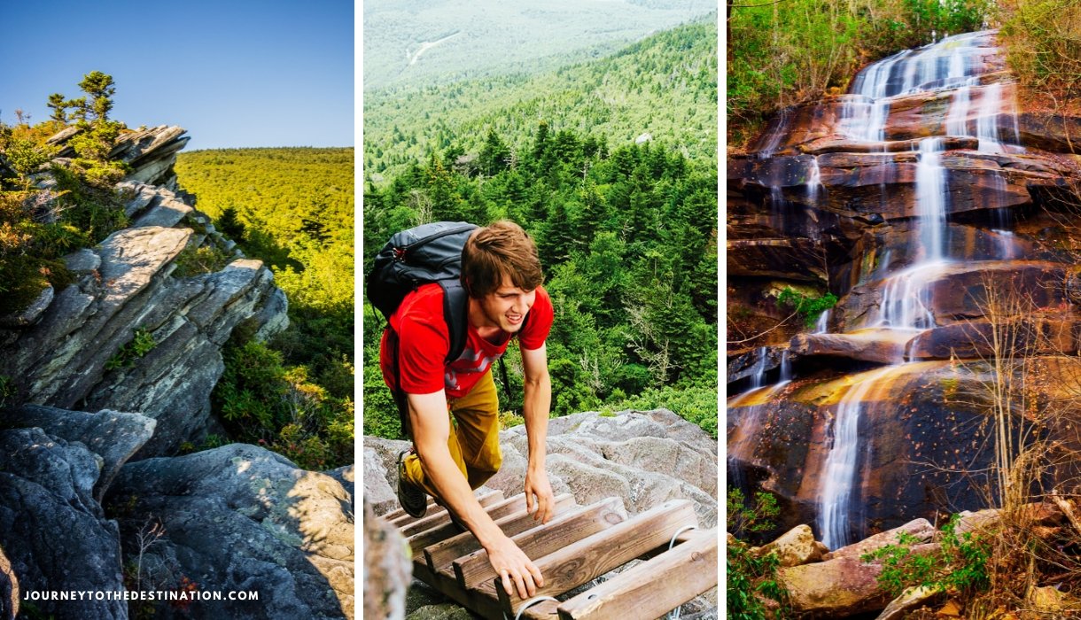
So, without wasting any time, I am taking you to “THE BEST HIKES NEAR ASHEVILLE.” Yes, mark my words, “THE BEST.” From easy to strenuous, there is a hike near Asheville for practically everyone, including family-friendly day walks, hiking trails next to breathtaking waterfalls, and summit treks with breathtaking vistas!
Imagine nibbling on wild berries, hiking up high, breezy cliffs with expansive views of the surrounding mountains, and strolling through meadows dotted with wildflowers as you cross over creeks with picturesque waterfalls! All of this and much more is available to you on the hikes near Asheville, North Carolina! So what are you waiting for, my dear travelers? Let’s jump into the list of best hikes below.
I have made the table below to accommodate all kinds of outdoor enthusiasts, from easy hikes to moderate to strenuous ones.
| EASY HIKES | MODERATE HIKES | STRENUOUS HIKES |
|---|---|---|
| Asheville Botanical Gardens Trails | Bearwallow Mountain Trail | Big Butt Trail |
| Bridal Veil Falls Hike | Craggy Pinnacle Trail | Cold Mountain Trails |
| Catawba Falls Trail | Daniel Ridge Loop Trail | Deep Creek Waterfall Hike |
| Hard Times Loop Trail | Graveyard Fields Loop Trail | Grandfather Mountain Trail |
The Best Hikes Near Asheville, North Carolina
Asheville hiking is fun. There are hundreds of hiking possibilities in Western North Carolina—are you overwhelmed?
#1 Asheville Botanical Gardens Trails

Asheville Botanical Gardens is a shaded urban oasis with a half-mile loop trail that emphasizes 600 species of native Southern Appalachian plants right north of the city center. Not overly formal, this botanical garden perfectly captures the essence of Asheville.
This garden promotes and researches native plants. To enjoy a slightly longer stroll, leave the gardens and head down the campus’s Reed Creek Greenway, which is accessible for both bicyclists and walkers. This is one of the most accessible hikes around Asheville.
Distance from Asheville: Approx. 1.5 miles
Length: 0.5-mile loop
Difficulty: Easy
Where: Find On Maps
#2 Bridal Veil Falls Hike

Considered among the best waterfall hikes around Asheville, Bridal Veil Falls in Dupont State Forest first caught the attention of moviegoers who saw The Hunger Games and the Last of the Mohicans on screen. Due to its abundance of natural features, DuPont State Forest is a well-liked location for outdoor activities.
Bridal Veil Falls can be reached in a variety of ways, but to keep things simple, take the Fawn Lake Access Area, which leads you down a number of wide gravel roads that are accessible to hikers of all ages.
These 120-foot waterfalls plummet and roar over bare granite stone. Walking beneath one of the rock ledges of Bridal Veil Falls is a popular activity that allows visitors to stand behind the 10-foot cascade at the top (as seen in a sequence from The Last of the Mohicans).
Hikers usually combine a trip to Bridal Veil Falls with another waterfall hike, such as a hike to Lake Julia or High Falls (accessed by returning to Conservation Road and following it to Buck Forest Road).
Distance from Asheville: About 38 miles; 50-60 minute drive
Length: 1.88 miles each way loop
Difficulty: Easy
Where: Find On Maps
#3 Catawba Falls Trail

Situated just 25 miles from Asheville’s center, Catawba Falls is a breathtaking sight, owing to its slew of falls that total 100 feet in height. The addition of two new footbridges to the easy-to-moderate route by the US. Forest Service has made it even more delightful, as you can now view the falls without having to rock-hop across the river.
Follow the nearly level trail from the parking lot that traces the old wagon route from Old Fort to Asheville. Along this walk are various early 1900s stone foundation remains, including the wall of a dam that was formerly built here in an attempt to generate hydropower. The trail stays near the water’s edge as it winds through the hardwood forest. This is also among the famous waterfall hikes near Asheville.
Distance from Asheville: About 25 miles; 30 minutes
Length: 1.5 miles each way; 3 miles round-trip
Difficulty: Easy
Where: Find On Maps
#4 Hard Times Loop Trail

Head out for a fun hike just 15 minutes away from the busy life of downtown Asheville. This cool trail, called the Hard Times Loop Trail, takes you through a place called Bent Creek Experimental Forest and the North Carolina Arboretum. You’ll see awesome views of mountains and Lake Powhatan, and even get a peek at the big, fancy Biltmore House.
This trail is pretty easy if you hike a lot or are active, but if you’re new to hiking, it might feel somewhere between easy and a little bit hard. Also, depending on where you start and which way you go, you can make the hike easier or a bit tougher. So, grab your hiking boots, and get ready to explore nature and have a great time on the trail.
Distance from Asheville: 15 minutes
Length: 6 miles
Difficulty: Easy
Where: Find On Maps
#5 Bearwallow Mountain Trail

Grab some snacks and hit the road to Bearwallow Mountain for a sweet hike that’s not far from Asheville. You can have a picnic and still get back to town with plenty of time for more fun stuff in the afternoon. There are two ways to get to the top: you can take an easy gravel road or a trail that zigzags up the mountain, making it cool for the whole family to try.
When you get to the top, which is way up at 4,232 feet, you’ll see some amazing sights. There’s a big open grassy spot where you can kick back and check out views that stretch all around. You can spot Mt. Mitchell and Mt. Pisgah, get a bird’s eye view of Hickory Nut Gorge, downtown Hendersonville, and even see far off into South Carolina.
Plus, there’s an old lookout tower and some cows that hang out at the top, which is pretty neat. So, for a fun adventure that’s close to home but feels a million miles away, Bearwallow Mountain is a great pick.
Distance from Asheville: About 19 miles; 30-35 minutes from downtown
Length: 1-mile trail to the meadow; 0.7-mile gravel access road
Difficulty: Moderate
Where: Find On Maps
#6 Craggy Pinnacle Trail

Looking for a quick adventure with epic views near Asheville? The Craggy Pinnacle Trail is your answer. Just a short trek through a tunnel-like rhododendron forest takes you to the top where you’re rewarded with breathtaking 360-degree views. Whether you catch a stunning sunset or the mystical morning mist over the mountains, it’s a sight to behold.
This trail packs a lot into just 1.4 miles round-trip. Climbing to the summit at 5,892 feet, you get a taste of the best mountain scenery around, including vast views, quirky twisted laurel, and dramatic rock formations.
The hike itself isn’t too tough and leads you through beautiful natural tunnels made of rhododendron bushes, past gnarled trees, and colorful wildflowers. Keep an eye out for side trails near the summit for extra exploration. For a short trip that gives you a big taste of what the Blue Ridge Mountains have to offer, Craggy Pinnacle is perfect.
Distance from Asheville: About 24 miles; 35-minute drive
Length: 1.4 miles total (Approx 0.7 miles each way)
Difficulty: Moderate
Where: Find On Maps
#7 Daniel Ridge Loop Trail

Check out Daniel Ridge Falls, a cool waterfall in Brevard that some people miss. It’s got a 150-foot drop and is also called Tom Spring Falls or sometimes Jackson Falls. This spot is pretty quiet, so you can enjoy a peaceful hike on a trail by the river with not many people around. You might see a mountain biker zoom past, but mostly you’ll hear the water and birds, which is pretty relaxing.
The Daniel Ridge Loop Trail itself is about 4 miles long and loops around, taking around 3 hours to finish. It’s a bit of a challenge but not too hard. Lots of people come here to camp, watch birds, and backpack, so you’ll probably see others out and about. The best time to go is from March to August. If you have a dog, they can come too, but you need to keep them on a leash.
Distance from Asheville: About 39 miles; 50-55 minutes
Length: 4-mile loop
Difficulty: Moderate
Where: Find On Maps
#8 Graveyard Fields Loop Trail

Graveyard Fields Loop Trail is a favorite spot near Asheville, and it’s easy to see why. This trail is about 3.5 miles long and takes around 2.5 hours to walk. It’s an easy path, so lots of people come here to hike and walk, meaning you’ll probably run into other folks enjoying the trail, too. You can bring your dog along, but make sure they’re on a leash. The best time to come is from March to November.
What’s so cool about it? You’ll get to see waterfalls, flowers called rhododendrons, beautiful trees in the fall, and even pick blueberries in the summer. Plus, there are wide open meadows and forests up high that look amazing. It’s especially great for families because there are different paths to choose from, so everyone can find something they like. That’s why pretty much everyone who likes hiking near Asheville ends up checking out Graveyard Fields.
Distance from Asheville: About 40 miles; 1 hour
Length: 3.5 miles total
Difficulty: Moderate
Where: Find On Maps
#9 Big Butt Trail

The Big Butt Trail might make you laugh with its name, but it’s a cool, high-up hike over 5,000 feet where it’s much cooler than in Asheville, 20 miles away. Perfect for escaping the summer heat, this 4.5-mile round-trip takes you through a dense forest to Little Butt Mountain. There, you’ll find a great spot for a picnic with awesome views of Mt. Mitchell.
The hike has its challenging parts, with plenty of ups and downs, including some steep areas. You’ll be walking through a cool, dense forest that feels like something from a fairy tale. The trail kicks off at Walker Knob Overlook, where you’ve got two paths to choose from. The one we’re talking about, Big Butt Trail, starts on the left side, behind a sign that points you towards “Little Butt 3 miles.” That’s not quite right, though—it’s a bit closer than that. Our target is Little Butt, since Big Butt doesn’t really have much to see.
Distance from Asheville: About 45 minutes
Length: 4.8 miles round-trip
Difficulty: Difficult
Where: Find On Maps
#10 Cold Mountain Trails
Cold Mountain is a tough hike, famous because of a book and a movie. It’s up in the mountains at 6,030 feet and the round trip is 10.6 miles. You’ll be hiking in a remote part of Pisgah National Forest. Plan for about 7 hours to hike it, and it’s best to go from May to October to dodge the snow.
The hike goes up 3,000 feet, so it’s steep but not too tricky. Remember to bring a lot of water. The hike starts at Daniel Boone Scout Camp and follows a path that’s easy to see but doesn’t have signs. You’re in for some awesome views and quiet time at the top.
Length: 10.6 miles round-trip for a strenuous hike
Difficulty: Difficult
Where: Find On Maps
#11 Deep Creek Waterfall Hike

Deep Creek is a fantastic spot in the Great Smoky Mountains National Park, close to Bryson City downtown. It’s famous for its beautiful scenery, including three awesome waterfalls. It’s a hit in the summer for camping and tubing down the creek. In other seasons, it’s quieter, making it a great place for a peaceful hike beside the rapids. This spot is also great in winter because it’s not too high up and hardly gets any snow. Remember, no pets are allowed here.
You can take a 5-mile loop hike to check out all three waterfalls or go for a shorter walk if you prefer. Tubing is big here, too, with one of the tubing routes going right past a waterfall! The trails used to be logging roads back in the day, and they used to float logs down the creek with splash dams. It’s a neat place with a bit of history and lots of natural beauty.
Distance from Asheville: About 65 miles, 1 hour 25 minutes
Length: 5-miles loop (or shorter if only doing sections)
Difficulty: Difficult
Where: Find On Maps
Related Articles
– Top 7 Things to Do in Bryson City, NC Should Be On Your List
– Ultimate Guide to Visiting Deep Creek, Bryson City – Great Smoky Mountains
#12 Grandfather Mountain Trail

The Grandfather Mountain Trail, known for its tough paths, is like an obstacle course in the sky. It’s a big deal for hikers who want a challenge because it’s full of spots where you have to climb using cables and ladders.
You’ll cross three peaks: McRae, Attic Window, and Calloway. This trail is not just a walk in the park; it’s more like a climb and scramble over some of the toughest trails in the East, but you don’t need any special climbing gear. It’s super important to know this trail is for those who have a lot of hiking experience. If you’re up for an adventure and ready to tackle some “chutes and ladders” without the board game, this is the spot.
Distance from Asheville: 70 miles, 90 minutes
Length: 2.4 miles each way to Calloway Peak
Difficulty: Difficult
Where: Find On Maps
Sponsored Feed
FAQ’s
Are there any dog-friendly hiking trails in the Asheville area?
Yes, several trails in the Asheville area are dog-friendly. Some popular options include the Bent Creek Experimental Forest, the Mountains-to-Sea Trail at the Blue Ridge Parkway, and the Dupont State Recreational Forest. Always remember to keep your dog on a leash and clean up after them.
What are the best hikes for waterfall enthusiasts near Asheville?
For those who love waterfalls, check out trails like Catawba Falls Trail, Bridal Veil Falls Trail, and Linville Falls Trail. These are some of the best waterfall hikes around Asheville, offering stunning waterfall views and perfect for photography enthusiasts.
Are there any trails suitable for families with young children?
Absolutely! Families with young children can enjoy trails like the Pink Beds Loop Trail, the Asheville Urban Trail, and the Lake Powhatan Loop Trail. These trails are relatively easy, shorter in distance, and provide lots of chances for exploring and having picnics.
What should I bring on a hike near Asheville?
It’s essential to be prepared when hiking. Make sure to bring plenty of water, snacks, a map or GPS device, proper footwear, sun protection (hat, sunscreen), a first aid kit, and layers of clothing for changing weather conditions. Additionally, consider carrying a fully charged phone and a whistle for emergencies.
Are there any hiking trails with accessible features for individuals with disabilities?
Yes, some trails around Asheville offer accessibility features. The French Broad River Greenway, Carrier Park, and the Asheville Urban Trail are some options with paved or smooth surfaces suitable for wheelchairs and strollers. Always check beforehand for current accessibility conditions.
What are some lesser-known hiking trails near Asheville?
If you’re looking to explore off the beaten path, consider trails like the Big Creek Trail in the National Park of the Great Smoky Mountains, the Shut-In Trail at Bent Creek Experimental Forest, and the Sandy Bottom Trail at Dupont State Recreational Forest. These trails offer quieter experiences and unique natural beauty.
Are there any hiking trails near Asheville that offer camping opportunities?
Yes, several trails in the Asheville area provide camping opportunities. Some notable options include the Art Loeb Trail, the Black Balsam Knob area on the Blue Ridge Parkway, and the Linville Gorge Wilderness. Remember to obtain any necessary permits and follow Leave No Trace principles when camping.
Can I hike in the winter near Asheville?
Yes, hiking in the winter near Asheville can be a beautiful experience. Trails like Mount Mitchell, Graveyard Fields, and Dupont State Recreational Forest offer unique winter scenery. However, be sure to check weather conditions and trail accessibility before heading out, and dress warmly in layers.


